RoomsSalas / RoomSala 004
Real and Imagined Maps: Measuring Is Also ImaginingMapas reales e imaginados: medir también es imaginar
Ancient maps, globes, navigation instruments and territories drawn from the imagination.
Mapas antiguos, globos terráqueos, instrumentos de navegación y territorios dibujados desde la imaginación.
13 pieces13 piezasNovember 2, 2026 – November 16, 20262 de noviembre de 2026 – 16 de noviembre de 2026JSON
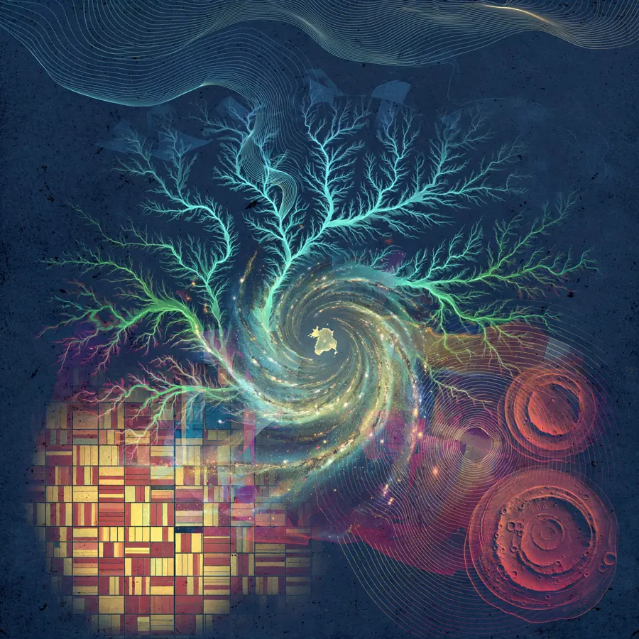
This room contains no parchment maps, globes, or compasses under glass, yet it speaks of nothing else. Its premise is a displacement: the map is no longer a sheet that precedes the journey, but an image produced afterward by instruments orbiting Earth and other worlds. It begins with a Space Shuttle simulator cockpit from 1980, all analog dials and artificial horizon, because before representing a territory one must learn to orient oneself within it. From there, the room moves through places that are real but barely recognizable: Howland Island reduced to a pale speck, the Himalaya without horizon, New York drawn only by its nighttime lights. The central argument is that every map chooses a sense and sacrifices the others. Optical photographs seem trustworthy because they resemble vision, but radar images, false-color infrared, and laser altimetry reveal what eyes cannot see: ice structure, sediment, vegetation, height, temperature. In the San Rafael and Malaspina glaciers, in the Mississippi and Sacramento deltas, color is not decoration; it is a translation. That translation can become so abstract that the territory turns into veins, patchwork, combed wood, or a surface under pressure. The room asks us to hold two things at once: these images are measurements, and they are also visual inventions. The final stretch leaves Earth to test that tension. Venus must be mapped by radar, Mars appears both as a Viking photographic mosaic and as MOLA topography, and Saturn's moon Mimas reveals a thermal figure nicknamed Pac-Man. The galactic exoplanet illustration closes the route because it cannot be a view from any possible window: it is a map of detections spread across the Milky Way. Real and imagined, then, are not opposites. They are degrees of mediation. A map is real when its data can be checked; it is imagined when we decide how that data should become visible. This room lingers exactly in that decision.
Esta sala no contiene mapas de pergamino, globos terráqueos ni brújulas en vitrina, y sin embargo no habla de otra cosa. Su premisa es un desplazamiento: el mapa ya no es una hoja que precede al viaje, sino una imagen producida después por instrumentos que orbitan la Tierra y otros mundos. Empieza con la cabina de un simulador del Transbordador Espacial de 1980, llena de diales analógicos y horizonte artificial, porque antes de representar un territorio hay que aprender a orientarse en él. Desde ahí recorre lugares reales pero apenas reconocibles: la isla Howland reducida a una mota pálida, el Himalaya sin horizonte, Nueva York dibujada solo por sus luces nocturnas. El argumento central es que todo mapa elige un sentido y sacrifica los demás. Las fotografías ópticas parecen confiables porque se parecen a la visión, pero las imágenes de radar, el infrarrojo en color falso y la altimetría láser revelan lo que el ojo no ve: estructura del hielo, sedimento, vegetación, altura, temperatura. En los glaciares San Rafael y Malaspina, en los deltas del Misisipi y de Sacramento, el color no es decoración; es una traducción. Esa traducción puede volverse tan abstracta que el territorio se convierte en venas, colcha de retazos, madera peinada o superficie bajo presión. La sala pide sostener dos cosas a la vez: estas imágenes son mediciones, y también son invenciones visuales. El tramo final sale de la Tierra para poner esa tensión a prueba. Venus debe cartografiarse por radar, Marte aparece como mosaico fotográfico Viking y como topografía MOLA, y Mimas, luna de Saturno, revela una figura térmica apodada Pac-Man. La ilustración galáctica de exoplanetas cierra el recorrido porque no puede ser la vista desde ninguna ventana posible: es un mapa de detecciones repartidas por la Vía Láctea. Lo real y lo imaginado, entonces, no son opuestos. Son grados de mediación. Un mapa es real cuando sus datos pueden comprobarse; es imaginado cuando decidimos cómo esos datos deben hacerse visibles. Esta sala se detiene exactamente en esa decisión.
The routeEl recorrido

Space Shuttle Simulator Cockpit, 1980Cabina del simulador del Transbordador Espacial, 1980
NASA · 1980-07-15
We begin before the map: with the instruments for not getting lost. This 1980 Space Shuttle simulator cockpit, full of analog dials, switches, and an artificial horizon, reminds us that every territory first arrives as readings. Before there is landscape, there is orientation.
Empezamos antes del mapa: con los instrumentos para no perderse. Esta cabina del simulador del Transbordador Espacial, de 1980, llena de diales analógicos, interruptores y un horizonte artificial, recuerda que todo territorio llega primero como lecturas. Antes que paisaje, hay orientación.

Howland Island as Seen from the International Space Station, December 3, 2004Isla Howland vista desde la Estación Espacial Internacional, 3 de diciembre de 2004
JSC · 2004-12-03
After the cockpit, the scale collapses: Howland Island is a pale, seed-shaped speck in an immense Pacific blue, seen from the International Space Station in 2004. On a conventional map it would have a name and a border; here it barely has presence. The piece asks how small a place can be before the map exaggerates it.
Después de la cabina, la escala se desploma: la isla Howland es una mota pálida, con forma de semilla, en un inmenso azul del Pacífico, vista desde la Estación Espacial Internacional en 2004. En un mapa convencional tendría nombre y borde; aquí apenas tiene presencia. La pieza pregunta qué tan pequeño puede ser un lugar antes de que el mapa lo exagere.

Himalayan Mountain Range Seen from Space Shuttle Columbia, 1981Cordillera del Himalaya vista desde el transbordador Columbia, 1981
JSC · 1981-04-14
From a nearly invisible island we move to the Himalaya photographed from Columbia in 1981, with no horizon or sky to give us scale. Snow, shadow, and folds turn the mountain range into crumpled paper or an unlabelled relief model. It converses with Howland by the opposite extreme: too much territory, not too little.
De una isla casi invisible pasamos al Himalaya fotografiado desde el Columbia en 1981, sin horizonte ni cielo que den escala. La nieve, la sombra y los pliegues convierten la cordillera en papel arrugado o en una maqueta de relieve sin rótulos. Conversa con Howland por el extremo opuesto: demasiado territorio, no demasiado poco.

New York at Night from the International Space StationNueva York de noche desde la Estación Espacial Internacional
Chris Hadfield · 2013-03-23
Night reverses the previous image: New York in 2013 is not drawn by mountains, but by golden filaments of artificial light and dark channels of water. The city appears only where it consumes energy. After the white Himalaya, this black map suggests that inhabiting is also a way of tracing.
La noche invierte la imagen anterior: Nueva York en 2013 no está dibujada por montañas, sino por filamentos dorados de luz artificial y canales oscuros de agua. La ciudad aparece solo donde consume energía. Tras el Himalaya blanco, este mapa negro sugiere que habitar también es una forma de trazar.

Space Radar Image of San Rafael Glacier, ChileImagen de radar espacial del glaciar San Rafael, Chile
NASA/JPL · 1999-04-15
The room changes language here: this is not an optical photograph, but a space-radar image of Chile's San Rafael Glacier, presented as a saturated diptych. Cyan, marine blue, and acid greens do not describe how the glacier looks, but how the sensor responds to it. Beside nocturnal New York, it shows another map made of signals rather than appearances.
Aquí la sala cambia de lenguaje: no es una fotografía óptica, sino una imagen de radar espacial del glaciar San Rafael, en Chile, presentada como un díptico saturado. El cian, el azul marino y los verdes ácidos no describen cómo se ve el glaciar, sino cómo responde el sensor ante él. Junto a la Nueva York nocturna, muestra otro mapa hecho de señales y no de apariencias.

Space Radar Image of Mississippi DeltaSpace Radar Image of Mississippi Delta
NASA/JPL · 1999-04-15
The Mississippi Delta, also in radar and false color, turns a river into veins or roots branching over a dark red surface. Read after San Rafael, it forces a distinction between ice and water when neither is blue nor white. The resemblance is in the instrument, not in the climate.
El delta del Misisipi, también en radar y color falso, convierte un río en venas o raíces que se ramifican sobre una superficie rojo oscuro. Leído después de San Rafael, obliga a distinguir entre hielo y agua cuando ninguno es azul ni blanco. El parecido está en el instrumento, no en el clima.

Malaspina Glacier in False ColorEl glaciar Malaspina en falso color
NASA/GSFC/METI/ERSDAC/JAROS, and U.S./Japan ASTER Science Team · 2002-02-26
The Malaspina Glacier in Alaska pushes abstraction further: electric turquoise ice presses against a granular brown-red moraine, with curved bands like combed wood. Compared with the Mississippi, the forms are less fluvial and more tactile. The map stops narrating a route and becomes a surface under pressure.
El glaciar Malaspina, en Alaska, lleva la abstracción más lejos: el hielo turquesa eléctrico empuja contra una morrena marrón rojiza y granulosa, con franjas curvas como madera peinada. Frente al Misisipi, las formas son menos fluviales y más táctiles. El mapa deja de narrar un recorrido y se vuelve una superficie bajo presión.

Sacramento-San Joaquin River Delta, CADelta de los ríos Sacramento y San Joaquín, California
NASA/METI/AIST/Japan Space Systems, and U.S./Japan ASTER Science Team · 2021-06-08
Human geometry returns, but without streets or buildings: the Sacramento and San Joaquin river delta appears as a patchwork of red, magenta, and pink parcels in false-color infrared. After Malaspina's natural pressure, this agricultural order feels artificial and yet equally abstract. The contrast asks where the natural ends in a cultivated territory.
La geometría humana vuelve, pero sin calles ni edificios: el delta de los ríos Sacramento y San Joaquín aparece como una colcha de parcelas rojas, magentas y rosas en infrarrojo de color falso. Tras la presión natural de Malaspina, este orden agrícola se siente artificial y, aun así, igual de abstracto. El contraste pregunta dónde termina lo natural en un territorio cultivado.
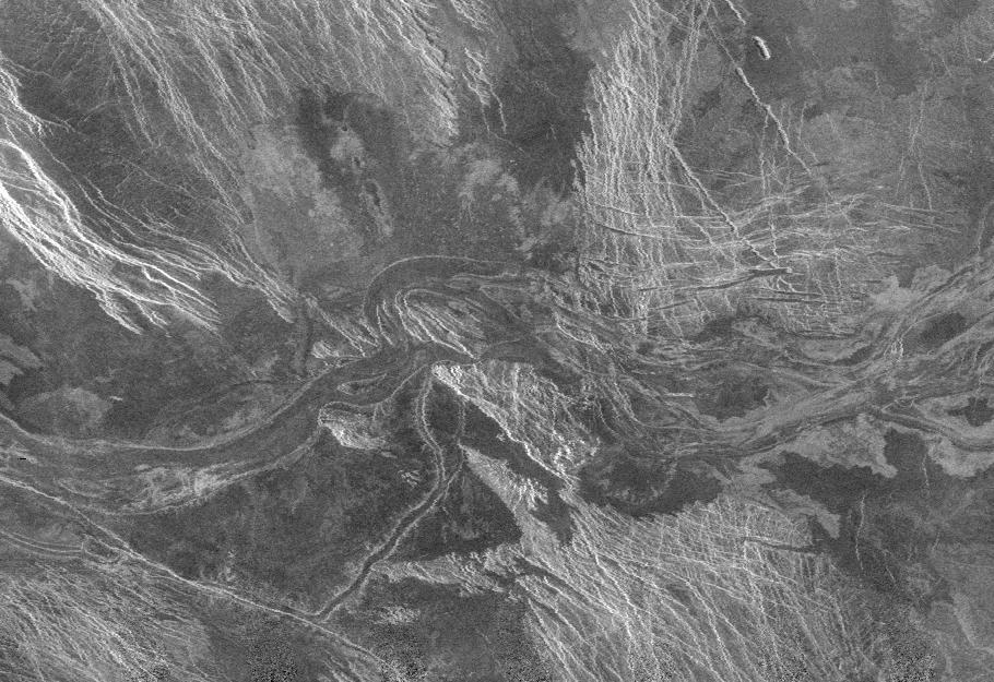
Lava Channel in Lada Terra, Venus – Radar Mosaic from the Magellan MissionCanal de lava en Lada Terra, Venus – mosaico de radar de la misión Magellan
NASA/JPL · 1996-02-01
We leave Earth through a surface that cannot be photographed in ordinary visible light: a lava channel in Venus's Lada Terra, mapped as a Magellan radar mosaic in black and white. The channel meanders like the Mississippi, but any river-like familiarity is deceptive. Here the previous deltas become a warning against reading other planets with Earthly habits.
Salimos de la Tierra por una superficie que no puede fotografiarse con luz visible ordinaria: un canal de lava en Lada Terra, Venus, trazado como mosaico de radar de Magellan en blanco y negro. El canal serpentea como el Misisipi, pero la familiaridad fluvial es engañosa. Aquí los deltas anteriores se vuelven una advertencia contra leer otros planetas con hábitos terrestres.

Mars: Valles Marineris Hemisphere Mosaic from Viking (1980)Marte: el hemisferio de Valles Marineris en mosaico Viking (1980)
NASA/USGS · 1980
Mars then appears as a complete sphere in the 1980 Viking mosaic, dominated by the scar of Valles Marineris and the Tharsis volcanoes named in its record. After Venus's grainy radar, this Mars looks almost photographic and recognizable. But it is still a mosaic: many views stitched into the illusion of a single gaze.
Marte aparece entonces como esfera completa en el mosaico Viking de 1980, dominado por la cicatriz de Valles Marineris y los volcanes de Tharsis mencionados en su ficha. Tras el radar granuloso de Venus, este Marte parece casi fotográfico y reconocible. Pero sigue siendo un mosaico: muchas vistas cosidas en la ilusión de una sola mirada.

Topography of Mars's Northern Hemisphere, MGS-MOLATopografía del hemisferio norte de Marte, MGS-MOLA
NASA/JPL/GSFC · 1997-10-13
The same planet is immediately unmade: the northern hemisphere of Mars rendered from MGS-MOLA laser altimetry in false-color topography. Beside the Viking mosaic, recognition gives way to height translated into color. The pair is the core of the room: one Mars to contemplate, another Mars to measure.
El mismo planeta se deshace de inmediato: el hemisferio norte de Marte representado desde la altimetría láser MGS-MOLA en topografía de color falso. Junto al mosaico Viking, el reconocimiento cede ante la altura traducida a color. La pareja es el núcleo de la sala: un Marte para contemplar, otro para medir.

The Pac-Man of Mimas: A Thermal Portrait of Saturn's MoonEl Pac-Man de Mimas: retrato térmico de una luna de Saturno
GSFC · 2017-12-08
The surprise comes with Mimas, a moon of Saturn shown in visible light on one side and as a thermal portrait on the other, producing the 'Pac-Man' effect named in its record. Temperature reveals a figure that the cratered surface did not announce. After Martian topography, it proves that an invisible variable can redraw a world as a character.
La sorpresa llega con Mimas, luna de Saturno mostrada en luz visible por un lado y como retrato térmico por el otro, con el efecto «Pac-Man» nombrado en su ficha. La temperatura revela una figura que la superficie craterizada no anunciaba. Tras la topografía marciana, prueba que una variable invisible puede redibujar un mundo como personaje.

Map of Exoplanets Found in Our Galaxy — Artist ConceptMapa de exoplanetas descubiertos en nuestra galaxia, ilustración conceptual
NASA/JPL-Caltech · 2015-04-14
We close by expanding the map until it can no longer be travelled: this 2015 conceptual illustration locates exoplanets discovered in our galaxy over a spiral Milky Way, linked in its record to Kepler, Spitzer, and microlensing. It is not a view from anywhere; it is a synthesis of detections. The room ends where mapping openly becomes imagination disciplined by data.
Cerramos ampliando el mapa hasta que ya no puede recorrerse: esta ilustración conceptual de 2015 ubica exoplanetas descubiertos en nuestra galaxia sobre una Vía Láctea espiral, vinculada en su ficha a Kepler, Spitzer y la microlente gravitacional. No es una vista desde ningún lugar; es una síntesis de detecciones. La sala termina donde la cartografía se vuelve abiertamente imaginación disciplinada por los datos.
Before you leaveAntes de irte
When a map is made of light, heat, radar, or gravity rather than coastlines, at what point do you stop reading a territory and start inventing it?
Cuando un mapa está hecho de luz, calor, radar o gravedad y no de costas dibujadas, ¿en qué punto dejas de leer un territorio y empiezas a inventarlo?